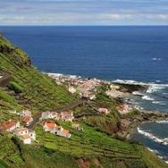
GRACIOSA
The White Island
Classified by UNESCO as a Biosphere Reserve, the island of Graciosa is the second smallest of the archipelago and is also the one with the least imposing terrain, with several flat areas and smooth hills. Pedras Brancas (White Stones), Serra Branca (White Hills) or Barro Branco (White Clay) are localities on the island whose name is related to the presence of a volcanic rock, the trachyte, which is common on the island and which, once rotten by the passing of time, gets a whitish colour which justifies the nickname of White Island.
Interactive Trail Map
Baia da Folga
Category - Linear
Difficulty - Easy
Extension - 2.1 km
Time average - 1h
This route begins in the centre of the village of Luz, near the local Holy Spirit chapel in the south of the island.
Start by going down the regional road for 600m and turn right at the dirt path. Follow the marks which will lead you along this path and through vineyards until you get close to the coast.
Follow the coastal path by some seaside goldenrods (Solidago sempervirens), African tamarisks (Tamarix africana) and endemic fescue (Festuca petraea) until you reach Portinho da Folga.
Serra Branca - Praia
Category - Linear
Difficulty - Easy
Extension - 8.7 km
Time average - 2h30m
This route goes through the island, sense West/East, beginning in the area of Serra Branca, an ensemble of volcanic structures made mainly by thick sediments of white trachytes that gives its name.
Begin the trail in Pico da Caldeirinha, near the Eolic Park and profit the high altitude to enjoy the view over the island.
Go round the volcanic cone on the right and arriving to the starting point, turn again to the right, facing East, crossing some ancient water reservoirs, along a road accessing pastures and agricultural fields. Pass by a pond following right until you reach the main road (EN3) that goes, on the right, to the area of Barro Branco.
Arriving to the fork, after the first houses, choose to go by a dirt alley on your left, along orchards and small woods. Near the main road (EN1-2) the trail proceeds inside the wood, mainly with Eucalyptus (Eucalytus globulus) and Australian Cheesewood (Pittosporum undulatum).
Cross the main road (EN1-2), pass through Lagoa and head to the seashore, passing by typical mills, some now Rural Tourism. Follow along the coast until Porto da Praia, place where this trail ends and where you can see the islet of Praia.
Volta à Caldeira - Furna do Enxofre
Category - Circular
Difficulty - Easy
Extension - 10.8 km
Time average - 3h
This small circular route surrounds the Natural Monument of Caldeira da Graciosa and also allows you to visit the famous Furna do Enxofre, a huge cave of lava origin that lies in its interior.
Begin the trail in the area of Canada Longa and follow the road towards Caldeira. At the first fork, choose right, passing by Furna do Abel, a lava tunnel. Continue, pass by Furna d’Água of smaller dimensions and with an underground water reservoir. Reaching the top of Caldeira, go left passing by Furna da Maria Encantada, known because of its collapsed lateral walls.
Continue the trail around Caldeira and profiting from the high altitude, enjoy the view not only of its interior as well as over the rest of the island. On the journey around Caldeira, prevails the guidance marks used on the Grand Routes.
Arriving again to the fork, choose left passing again by Furnas d’Água and Abel and on the main road, go right, passing by the accessing tunnel to the interior of Caldeira. Continue along the road until you reach a stairway to access Furna do Enxofre, geosite where there is an Interpretative Centre which is also the entry. In the period between 11h00 and 14h00 it is possible to see the cave from the outside, due to the rays of sunshine coming inside.
After the visit to this magnificent place, make the inverse way, passing by the tunnel and finishing the trail at the starting point, in the area of Canada Longa.


